Plotting My Air Flight Path from Photos

In summary, the photos I took show a flight path over water, but when I try to map the flight path on a map based on the photos, the path does not match. I am now stuck trying to find the path in cities that I took photos of a few hours earlier.
  • #1
DaveC426913
Gold Member
22,505
6,175
I expected this to be challenging but it's turning out to be much harder than I expected.

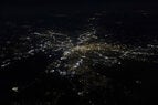
I just flew back from Cuba to Toronto, got in at 315AM. It was a beautiful, clear and I had the window seat, so I took a bunch of pics. Now I'm plotting the flight path by analyzing the photos. It's super easy over bodies of water but in the interior, everything looks very much alike. (Too bad my camera doesn't imprint GPS coords in its EXIF data, eh?)

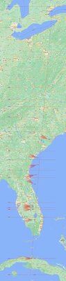
I know our cruise altitude was said to be 38,000 feet, the path is 2,450km (give or take, as the crow flies) and our air speed was somewhere between 815 and 850km/h. (Normally the cruise speed would be 800km/h, but we were late so the pilot tried to shave 15 minutes off). I was sitting on the port side, looking west and northwest. I plotted a time map based on idealized flight data just to narrow down the observation points, knowing all variables are imprecise.

But it's getting harder and harder the farther north I get. I'm stuck on this city - the largest one since passing Fort Myers. The pic was taken at 1:42AM, which is 100 minutes into the flight. That should put me just shy of Charlotte (where the vertical (ideal) flight path crosses the horizontal 0142 latitude on my map). The photo is looking North West.

But try as I might, I can't get any city on my map to look like that photo. And I'm only halfway home! I've got a dozen more cities to locate.

...

Don't really have a question, just trying to share the pain and maybe crowd-source a little.

(I have full scale map and images, but won't upload them unless/until I generate some interest.)
 

Attachments

  • 0142AM North West.jpg
    0142AM North West.jpg
    44.4 KB · Views: 65
  • flight home.jpg
    flight home.jpg
    14.2 KB · Views: 77
Physics news on Phys.org
  • #2
There's no better way to solve a problem than to despair and write a letter to others.

I had the idea of looking for satellite photos, which tend to be more faithful to the light and darks of the nighttime shots I'm taking.

Here is a sat photo of Charlotte, looking from the S.E, which is an excellent match to my photo:

lt_clt_1.jpg


Still, that's just one of a dozen to go.
 
  • #3
Have you tried starting in Toronto and working backwards?
Also you could watch the flight on Flightaware and try to match it up?
Looking at Google Map (photo) your photo looks more like Colombia S.C. to my eye. I love google map.
 
  • #4
hutchphd said:
Have you tried starting in Toronto and working backwards?
Alas, alack. For all that it was clear for the first leg, it clouded over for the last hour. Nothing visible until we were on apprach.

hutchphd said:
Also you could watch the flight on Flightaware and try to match it up?
OM, that's brilliant! I can literally screen print the actual path and drop it on my map!
hutchphd said:
Looking at Google Map (photo) your photo looks more like Colombia S.C. to my eye. I love google map.
Indeed. Evidence of how challenging this is. I've been at this for about 12 hours. I have rejigged the map a dozen times.

This is Charlotte:
\
1673156129748.png
 
Last edited:
  • Like
Likes hutchphd
  • #5
  • #6
Asheville? It is nearly surrounded by mountains that should have few lights at night.
 
  • #7
DaveC426913 said:
OM, that's brilliant! I can literally screen print the actual path and drop it on my map!
Be aware of little variations in flight path for takeoff and landing approach based on wind directions, as well as any strong storm location, at the actual time of your trip.
FlightAware provides accurate real-time locations and altitudes; therefore, the path that you can now see for your flight number and day of the week may be slightly different.
Did you fly from Havana city heading North?
 
  • Like
Likes russ_watters
  • #8
flightradar24.com also gives actual flight path.
 
Last edited:
  • Like
Likes hutchphd, Lnewqban and anorlunda
  • #9
russ_watters said:
Use flightradar24.com to get also gives actual flight path.
Yes, but don't forget the 5 minute delay in the "real time" position. That's required by the FAA, and it helps to make life harder for terrorists who would target an airplane.

At 350 knots, 5 minutes is about 50 km.

You can also legally use a software defined radio dongle with your phone to directly receive your plane's ADS-B transmission. But it would quickly run down your phone's battery.

I never tried it, but you may also be able to use Google Maps in flight, or one of the many apps for iPad that general aviation pilots use as chart plotters. Come to think of it, you have myriad methods in today's modern world.

The next time you fly, try asking ChatGPT, "where am I?" Also, hope that your pilot is not doing the same. :wink:
 
  • Like
  • Haha
Likes DaveC426913, russ_watters and Lnewqban
  • #10
Bad edit on that last posts...two competing phrasings...
anorlunda said:
Yes, but don't forget the 5 minute delay in the "real time" position. That's required by the FAA, and it helps to make life harder for terrorists who would target an airplane.
You sure about that? I use flightradar24 all the time to identify planes overhead.
I never tried it, but you may also be able to use Google Maps in flight, or one of the many apps for iPad that general aviation.
You can/I do, but you pretty much need to hold the phone against the window.
 
  • #11
russ_watters said:
You sure about that? I use flightradar24 all the time to identify planes overhead.
From their FAQ. It depends on the color.
What is the difference between the yellow and the orange planes?
In addition to ADS-B data, we also display data from the Federal Aviation Administration (FAA). This data provides full coverage of the airspace above the United States and Canada. However, this data is slightly delayed (up to 5 minutes) due to FAA regulations. Because of this delay, the planes generated from FAA data are of a different color (orange) than the planes generated from real-time data (yellow).

Edit: It reminds me of the recent news about Elon Musk objecting to people tracking his airplane making him an assassination target. With real time data, an assassin could even set up an automated weapon near a runway. It could be triggered to fire when the targeted tail-number goes past.
 
  • #12
russ_watters said:
flightradar24.com also gives actual flight path.
Oof! Not only does that show me the actual fight path, but it has a playback feature that times the path down to the minute!

This project has gone from challenging to trivial! :sorry: :woot:
 
  • Like
Likes berkeman, russ_watters and Lnewqban
  • #13
Welcome to the future, where we are all assimilated.........
 
  • Like
  • Haha
Likes Tom.G, anorlunda and russ_watters
  • #14
anorlunda said:
From their FAQ. It depends on the color.
Interesting. I'm not clear on the source of "FAA Data" (radar?), but such planes are likely rare since ADS-B is required within 30 miles of big airports. So that covers almost all airliners and most small planes. Zooming out on the US I don't see any orange, but see a few blue over the oceans.

Not here nor there, but military also usually doesn't show up at all.
 
  • #15
russ_watters said:
Not here nor there, but military also doesn't show up at all.
Naturally. There is a similar system for ships called AIS. Military ships don't do that either. It makes sense because the enemy could use that signal to locate a target.

Most annoying, military ships also would not answer calls on VHF channel 16, even when collision avoidance was the purpose of the call. We had a submarine surface in front of our sailboat one night. We had to take emergency avoidance maneuvers, but the sub refused to answer our calls.
(Submerged subs detect propeller noise of motorboats, but they can't hear sailboats.)
 
  • Wow
Likes hutchphd and berkeman
  • #16
anorlunda said:
(Submerged subs detect propeller noise of motorboats, but they can't hear sailboats.)
Sure they can! Sailboats sound like "SUNUVA@#$*HARDABOUT@$#*$!!&#$**SUBCAPTAINGOT#$&@LICENCEOUTOFA%#@*%@#*CRACKERJACKBOX"
 
  • Haha
Likes Tom.G, berkeman, anorlunda and 1 other person
  • #17
I could rent myself out for overnight protection. Apparently my snoring apparatus is resonant with some of the fundamental frequencies of a thirty foot Pearson sailboat hull. By unanimous consent I was banished to sleep above deck. There were many mosquitos above deck.
 
  • Like
  • Haha
Likes russ_watters and berkeman
  • #18
OK. Three days and I'm done.

I was going to do it as a single infographic-like image but the visual scales are too widely divergent. A map that shows sufficient geographical detail is too large to show onscreen without prodigious scrolling. So I decided to add some basic interactivity to add the details on an overlay.

It could use a lot of 'sugar' and attention to user experience before I'd release it into the wild, but it has sated a desire in me to do some data forensics and visualization. (I really dream of having my next career be in GIS visualization.)

Behold the awesomeness that is Flight WG265 from Cayo Largo to Toronto:
https://www.davesbrain.ca/adventures/23cuba/

Thanks all!
 
  • Like
Likes hutchphd, Tom.G, russ_watters and 1 other person
  • #19
Nice!!

A couple minor enhancement ideas:

. Making the pop-ups of Observation Cones scrollable
. Some way of showing which Observation Cone is being shown in the pop-up
(Show Observation number in pop-up, or change color of cone?)

Cheers,
Tom
 
  • Like
Likes DaveC426913
  • #20
Look like Columbia SC which is about half way between Cuba and Toronto and 100 minutes into a (?) 200 minute +/20% flight.
0142am-north-west-jpg.jpg

1682971915295.png


I give this a 75% confidence as it is between Ft Meyers and Charlotte and has a similar city and highway pattern. But I had no idea on departure city or flight number.

Would recommend the hotel in Cayo Largo?
 
Last edited:
  • #21
TonyStewart said:
Look like Columbia SC which is about half way between Cuba and Toronto and 100 minutes into a (?) 200 minute +/20% flight.

I give this a 75% confidence as it is between Ft Meyers and Charlotte and has a similar city and highway pattern. But I had no idea on departure city or flight number.
It is indeed Columbia.
https://www.davesbrain.ca/adventures/23cuba/
TonyStewart said:
Would recommend the hotel in Cayo Largo?
Well, this is our eighth or ninth visit to the same hotel, so you be the judge... :wink:
 
  • #22
DaveC426913 said:
Well, this is our eighth or ninth visit to the same hotel, so you be the judge... :wink:
I thought that you were visiting the biggest island of the archipelago... :smile:
 
  • #23
DaveC426913 said:
It is indeed Columbia.
https://www.davesbrain.ca/adventures/23cuba/
Well, this is our eighth or ninth visit to the same hotel, so you be the judge... :wink:
Ok but I'm not a mind reader or I missed it somewhere.
 
  • #24
Lnewqban said:
I thought that you were visiting the biggest island of the archipelago... :smile:
More like one of the tiniest.
https://www.google.com/maps/place/Memories+Cayo+Largo/@21.5999491,-81.5303387,356m

You can walk its length in a couple of hours. There are no permanent residents. All staff are flown in for their three week stints.

The real beauty is the convenience. Despite being tiny, it has direct non-stop flights from Toronto airport weekly. And the hotel is a ten minute bus ride from the airport. Travel stress is, like zero.
 
  • Like
Likes Lnewqban
  • #25
TonyStewart said:
Ok but I'm not a mind reader or I missed it somewhere.
I was just concurring with you.
Post 18 has a link to the final product with all points of interest labeled.
 

Related to Plotting My Air Flight Path from Photos

1. How do I plot my air flight path from photos?

To plot your air flight path from photos, you will need to use a mapping software or app that allows you to input coordinates and create a route. You can also manually trace your flight path on a map using the photos as a reference.

2. Can I use any type of photo to plot my air flight path?

Ideally, you should use high-resolution photos with clear landmarks or reference points to accurately plot your air flight path. Aerial photos or satellite images are typically the best options for this task.

3. Do I need to know the exact location of each photo to plot my air flight path?

Having the exact location of each photo will make the plotting process more accurate. However, if you do not have this information, you can estimate the location by using other reference points in the photo or by using a mapping software that allows you to adjust the location of the photo manually.

4. How can I ensure the accuracy of my plotted air flight path?

To ensure the accuracy of your plotted air flight path, it is important to use high-quality photos, have a clear understanding of the mapping software or app you are using, and double-check your route by comparing it to other sources such as a flight plan or GPS data.

5. Are there any limitations to plotting my air flight path from photos?

While plotting your air flight path from photos can be a useful tool, it may not always be 100% accurate due to factors such as the quality of the photos, the accuracy of the mapping software, and the availability of reference points. It is important to use this method as a guide and not rely solely on it for navigation purposes.

Similar threads

  • Astronomy and Astrophysics
Replies
4
Views
2K
  • Introductory Physics Homework Help
Replies
1
Views
2K
  • General Discussion
2
Replies
43
Views
6K
  • Introductory Physics Homework Help
Replies
2
Views
12K
  • Sci-Fi Writing and World Building
Replies
2
Views
2K
  • STEM Academic Advising
Replies
13
Views
4K
Back
Top