Major Tropical Cyclone NE Australia

In summary, Cyclone Debbie caused widespread flooding and destruction in Queensland, including Luscombe where a house floated away.
  • #1
davenn
Science Advisor
Gold Member
2023 Award
9,598
10,333
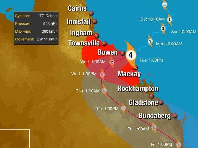
Cyclone Debbie is a major CAT 4 storm at the time it hit the Queensland coast in the Bowen area. It has sustained winds near the centre of 185 kilometres per hour with wind gusts to 260 km/hr have been recorded.
The Bureau of Meteorology (Australian weather service) suggest the possibility that gusts could exceed 270 km/hr near the eye.
High storm surges have already been recorded along the coast.
The storm is expected to deteriorate quickly after it is over land and away from the warm tropical seas.

Satellite image at 1200 hrs AEST ( Australian Eastern Standard Time), 28th March 2017

170328 1200EST Cyclone Debbie FNQsm.jpg


170328 Debbie storm track.jpg
it's a bit more than 1500km north of my location

Dave
 
Earth sciences news on Phys.org
  • #2
I hope @Math Amateur is fine. He told he would be traveling in Queensland ... I hope he meant Brisbane.
 
  • Like
Likes davenn
  • #3
ohhh and a weather radar that includes lightning data

170328 1200EST Cyclone Debbie FNQ radar.jpg
 
  • Like
Likes SW VandeCarr
  • #5
OmCheeto said:
Is it safe to assume you missed the "900 mm" rainstorm?

fortunately ! ... we have had quite a bit of rain in my region recently, but nothing like what they have had up north because of the cyclone

... the cyclone has been gone for almost a week but there are still areas going under flood waters up north because it has taken time for all the water in the tributaries to make it down into the main river course and cause it to flood the main river through the city of Rockhampton is a one of those and by lunch time tomorrow it is expected to peak at approx. 9 metres above normal level

Dave
 
Last edited:
  • Like
Likes OmCheeto
  • #6
davenn said:
fortunately ! ... we have had quite a bit of rain in my region recently, but nothing like what they have had up north because of the cyclone

... the cyclone has been gone for almost a week but there are still areas going under flood waters up north because it has taken time for all the water in the
tributaries to make it down into the main river course and cause it to flood
the main river through the city of Rockhampton is a one of those and by lunch time tomorrow it is expected to peak at approx. 9 metres above normal level

Dave
It's hard for me to imagine that much rain, in such a short period of time, as that's approximately our annual average here: 915 mm
 
  • #7
OmCheeto said:
It's hard for me to imagine that much rain, in such a short period of time, as that's approximately our annual average here: 915 mm
It took some time for me to find a link, I was trying to get my head around how much rain fell compared to what happened near my location a few years ago... 19" in six hours :wideeyed:
http://blogs.wsj.com/numbers/how-much-rain-fell-in-marble-falls-texas-138/

The 900mm was spread out for 48 hours, but still "when you are flooded, you are flooded" :frown:
 

Related to Major Tropical Cyclone NE Australia

1. What is a major tropical cyclone and how is it different from a regular cyclone?

A major tropical cyclone is a large, rotating storm system that forms over warm ocean waters and has wind speeds of at least 111 miles per hour. It is classified as a major tropical cyclone when it reaches Category 3 or higher on the Saffir-Simpson Hurricane Wind Scale. This means that it is a much stronger and more intense storm than a regular cyclone, which typically has wind speeds of 74-95 miles per hour.

2. Where is NE Australia and why is it prone to major tropical cyclones?

NE Australia refers to the northeastern region of Australia, which includes the states of Queensland and parts of New South Wales. This area is prone to major tropical cyclones due to its location in the tropics, warm ocean temperatures, and favorable atmospheric conditions for storm development. In addition, NE Australia is a popular tourist destination and has a high population density, making it more vulnerable to the impacts of major tropical cyclones.

3. How are major tropical cyclones named and why?

Major tropical cyclones are named by the World Meteorological Organization (WMO) based on a pre-determined list of names for each ocean basin. The names are chosen to be easily recognizable and to avoid confusion between storms. They are also used to raise awareness and aid in storm tracking and communication between different agencies and countries.

4. What are the potential impacts of a major tropical cyclone on NE Australia?

The impacts of a major tropical cyclone on NE Australia can be devastating. The strong winds can cause widespread damage to buildings and infrastructure, while heavy rainfall can lead to flash flooding and landslides. Storm surge, or the rise in sea level caused by the cyclone's winds, can also cause significant coastal flooding. In addition, major tropical cyclones can disrupt transportation, communication, and power systems, and pose a threat to human life and safety.

5. How do scientists track and predict the path of a major tropical cyclone?

Scientists use a variety of tools and techniques to track and predict the path of a major tropical cyclone. These include satellite imagery, Doppler radar, weather balloons, and computer models. By analyzing data such as wind speed, atmospheric pressure, and temperature, scientists can create forecasts and predict the potential impacts of the cyclone. However, it is important to note that predicting the precise path and intensity of a major tropical cyclone can be challenging and there is always some degree of uncertainty involved.

Similar threads

Replies
39
Views
7K
Replies
4
Views
2K
  • Earth Sciences
Replies
13
Views
3K
Replies
6
Views
3K
Replies
2
Views
2K
Back
Top